Charlemont Place On The Grand Canal - Presented By The Urban Cartographer
LET MISTER SCREEN ASSIST YOU
GLOBAL INDEXThe Urban Cartographer
TECHNICAL STUFFDiscover the transformation of Charlemont Place along Dublin’s Grand Canal. From its 18th-century industrial roots to the modern Charlemont Square development, explore the history, current commercial status, and the legality of the iconic residential barge homes on the north bank.
EXCELLENT PICTURE THIS 2017
Charlemont Place On The Grand Canal - Presented By The Urban Cartographer
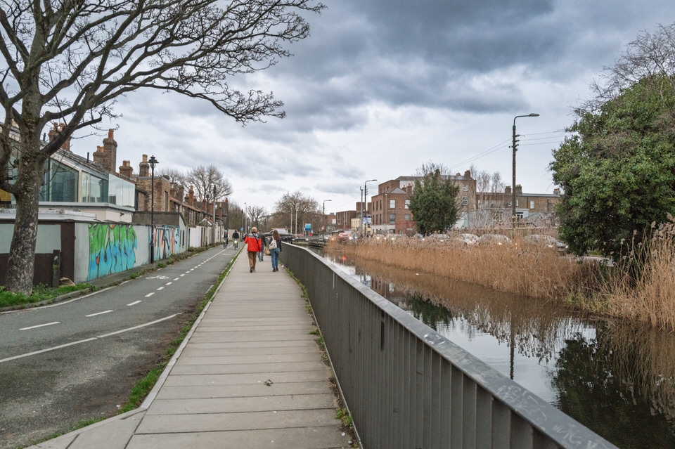
Charlemont Place On The Grand Canal
Author: Urban Cartographer
|
15. Feb 2026
Select Image Below To Visit The Photo Gallery: Charlemont Place On The Grand Canal Photographed By William Murphy - Select Image To View Photographs

Charlemont Place, situated along the north bank of the Grand Canal in Dublin 2, has evolved from a 18th-century industrial artery into one of the city’s most premium commercial and residential quarters. Today, it serves as a bridge between the historic "Circular Line" of the canal and the ultra-modern architecture of the Dublin 2 business district.
A Brief History
The history of Charlemont Place is inextricably linked to the Grand Canal, which began construction in 1757 to connect Dublin to the River Shannon.
The Circle Line: The section of the canal at Charlemont Place was part of the "Circle Line" through Dublin, which opened in 1796. It served as a vital transport route for turf, grain, and Guinness.
The Charlemont Name: Named after James Caulfeild, the 1st Earl of Charlemont, a prominent patron of the arts. While his primary seat, Charlemont House, is on Parnell Square, his influence shaped the naming of this southern city stretch.
Industrial to Residential: By the 20th century, the area was dominated by social housing (the Charlemont Street flats) and small-scale industry. In the 1960s, it narrowly escaped being paved over for a six-lane dual carriageway.
Current Status (2026)
Charlemont Place is currently in its "Grand Canal Renaissance" phase. The area has been completely transformed by massive regeneration projects:
Charlemont Square: This is the flagship development of the area, a €210 million mixed-use district completed around 2024. It features Grade A office space (housing major tech and finance firms), over 280 luxury apartments, and a central public plaza with retail and dining.
Charlemont Exchange: A major refurbishment of older office blocks that now overlooks the canal, focusing on sustainability and LEED Gold standards.
The Luas Green Line: The Charlemont Luas stop remains one of the busiest in the city, providing a direct link to both the north city centre and the southern suburbs.
The Barge Homes: Are They Legal?
The sight of the two "barge homes" (often referred to as houseboats) at Charlemont Place is a iconic part of the local scenery. Their legal status is governed by Waterways Ireland under the Canals Act 1986 (Bye-Laws).
Legality: Yes, they are legal, provided they hold a Residential Extended Mooring Permit (R-EMP).
The Permits: Waterways Ireland offers specific permits for those wishing to use their vessel as a primary residence. As of the latest regulations, a residential permit costs approximately €578 per annum (including a service charge).
New Regulations (2024/2025): There has been a recent push to "regularise" houseboats. New bye-laws introduced in 2024 aim to increase the number of official serviced moorings (with water and electricity) while tightening restrictions on "informal" or long-term mooring without a specific residential permit.
The "Two Barges": These specific vessels are well-known fixtures. Because they occupy a prime location, they are subject to strict adherence to safety and aesthetic standards set by the canal authorities to ensure they don't obstruct navigation or the public towpath.
The MetroLink project is the single most significant infrastructure development in Charlemont's history. As of early 2026, the project has transitioned from a decade of planning into the "enabling works" phase, following the granting of the Railway Order (planning permission) in late 2025.
The Plans for Charlemont
Charlemont has been designated as the Southern Terminus for the 19km MetroLink line. This makes it the primary interchange for passengers travelling from the south of the city (via the Luas Green Line) to Dublin Airport and Swords.
Station Design: The new MetroLink station will be a deep-bore underground station. Unlike the current Luas stop, which is elevated, the Metro station will be situated significantly below ground level to clear existing utilities, including a massive Victorian-era sewer under the Grand Canal.
The "Turnback" Facility: Because Charlemont is the terminus, a large "turnback" tunnel will be constructed south of the station. This allows trains to switch tracks and head back north. This specific requirement is why the construction footprint in the area is so much larger than at other stops.
Dual Entrances: To manage high passenger volumes, the plan includes two main entrances:
Canal Side: Integrating with the existing Charlemont Luas stop for seamless transfers.
Dartmouth Square West: A second entrance on the south side of the canal to provide access for the Ranelagh community.
Key Impacts
Connectivity and Economic Growth
Charlemont will become one of Dublin’s most vital transport "hubs." A journey from the canal to Dublin Airport will take approximately 20 minutes, a radical improvement over current bus or taxi times. This is expected to further increase the desirability of office spaces in the neighbouring Charlemont Square.
Construction Disruption (2026–2032)
Construction is expected to be intensive.
Road and Towpath Closures: Portions of the Grand Canal towpath and nearby Northbrook Road are expected to face periodic closures or diversions to accommodate heavy machinery.
Noise and Vibration: Given the depth of the station and the nature of the "turnback" tunnel, residents in the immediate vicinity (especially those in redbrick period homes) have expressed concerns regarding structural vibration.
Property and Residential Settlement
In a landmark move in late 2025/early 2026, the State reached a €30 million settlement with a group of residents at Dartmouth Square West.
Voluntary Purchase: To avoid a lengthy High Court battle that would have delayed the project by years, the State offered to buy approximately 10 to 15 homes directly affected by the tunnel works.
Future Resale: These properties will likely be used as construction offices or temporary housing for engineers before being restored and resold to the private market once the project is completed (estimated mid-2030s).
Impact on the "Barge Homes"
During the heavy construction phases, there may be temporary restrictions on mooring in the immediate "splash zone" of the station box construction. However, the long-term plan retains the canal’s character, and the new station is designed to sit beneath the water level without permanently displacing the canal's resident vessels.
GALWAY CITY
CORK CITY AND COUNTY
GLOBAL MENU
DUBLIN SOUTHSIDE
DUBLIN NORTHSIDE
URBAN CARTOGRAPHER
EXCELLENT PICTURE THIS 2017
Charlemont Place On The Grand Canal - Presented By The Urban Cartographer
Who Is Building An Experience Which Is Getting Better Day By Day