The Wonderful Blackrock Linear Park - Presented By The The Urban Cartographer
LET MISTER SCREEN ASSIST YOU
GLOBAL INDEXThe Urban Cartographer
TECHNICAL STUFFExperience the beauty of the coastal linear park between Booterstown and Blackrock. This guide details the scenic walking route from Booterstown Station, through the protected saltmarshes and reclaimed Victorian parklands, ending at the historic Blackrock Station. Perfect for birdwatchers, history enthusiasts, and casual walkers.
EXCELLENT PICTURE THIS 2017
The Wonderful Blackrock Linear Park - Presented By The The Urban Cartographer
The Wonderful Blackrock Linear Park
Author: The Urban Cartographer
|
09. May 2026
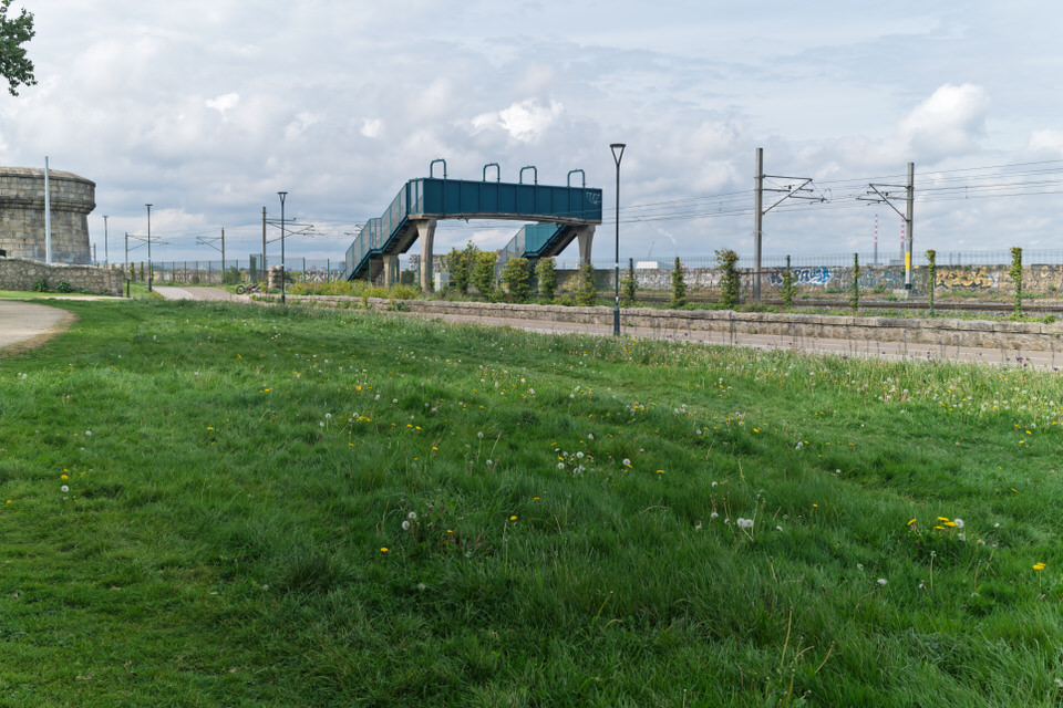
The coastal stretch between Booterstown and Blackrock offers one of Dublin’s most scenic and ecologically significant walks. This linear park follows the path of the Dublin and Kingstown Railway, providing a unique corridor where Victorian engineering meets modern conservation. Starting Point: Booterstown Station to the Marsh The journey begins at Booterstown DART Station. Immediately to the west lies the Booterstown Nature Reserve, the only remaining saltmarsh on the south side of Dublin Bay. The Causeway Path: Walking southward, the path is flanked by the railway line on the left and the marsh on the right. This area is a prime location for observing the Light-bellied Brent Goose during winter months. Historical Context: This section of the park exists largely because the railway embankment, constructed in the 1830s, enclosed the marshland and protected it from total erosion by the sea. The Mid-Section: Williamstown and Reclamation As the path continues toward Blackrock, it passes through the area formerly known as Williamstown. Landscaped Greens: The linear park widens here into a series of manicured lawns and wildflower meadows. The transition from the rugged marshland to more formal parkland reflects the Victorian desire to "tame" the coastline for public recreation. Flora and Fauna: The park serves as a "green lung" for the city. Mature trees and hedgerows provide nesting sites for songbirds, while the open grass areas are popular for local walkers and joggers. Arrival: Blackrock Park and the Pond The walk culminates in the northern entrance of Blackrock Park. This final stretch is dominated by the large ornamental pond, which was originally a mudflat reclaimed during the 19th century. Victorian Elegance: The path leads past the elevated stage area and the historic bandstand, offering views of the granite outcrops that gave Blackrock its name (Carraig Dhubh). The Finishing Line: The walk concludes at Blackrock DART Station, where the yellow-brick Victorian station building serves as a fitting end to a journey through Dublin’s transport and natural history. Practical Information Distance: Approximately 1.8 kilometres. Terrain: Flat, paved paths suitable for all fitness levels, wheelchairs, and prams. Amenities: Seating is available at regular intervals, with coffee shops and public facilities located in Blackrock Village at the end of the route. Blackrock Linear Park - Select Image To View Photographs
Temple Bar - Select Image To View Photographs Blackrock Train Station - Select Image To View Photographs
 The Pond Area - Select Image To View Photographs
 Booterstown - Select Image To View Photographs
 Cut Out People 2026 - Select Image To View Photographs
 View The Sculpture - Select Image To View Photographs
 Mister Magpie Cafe - Select Image To View Photographs
 Graffiti Is Illegal In Ireland - Select Image To View Photographs
 The Street Art - Select Image To View Photographs
 As It Was In 2016 - Select Image To View Photographs
 Camden Yard - Select Image To View Photographs
 Abstract Sculptures - Select Image To View Photographs
 An Amazing Tree - Select Image To View Photographs
 Old Churchyard - Select Image To View Photographs
VIEW HI-RES PHOTOGRAPHS
FUJI X100VI PHOTO COLLECTION
ABOUT THE LINEAR PARK
GLOBAL INDEX OF PHOTO GALLERIES
PARKS AND GARDENS
THE URBAN CARTOGRAPHER
EXCELLENT PICTURE THIS 2017
The Wonderful Blackrock Linear Park - Presented By The The Urban Cartographer
Who Is Building An Experience Which Is Getting Better Day By Day