O'Devaney Gardens As It Was In 2021 - Presented By The Urban Cartographer
LET MISTER SCREEN ASSIST YOU
GLOBAL INDEXThe Urban Cartographer
TECHNICAL STUFFA photographic comparison of the O'Devaney Gardens area in Dublin 7, contrasting the eerie COVID-19 lockdown silence of February 2021 with the massive "canyon effect" of the new high-rise redevelopment in February 2026. Explore the Viking heritage of Thor Place and the changing face of Stoneybatter.
EXCELLENT PICTURE THIS 2017
O'Devaney Gardens As It Was In 2021 - Presented By The Urban Cartographer
O'Devaney Gardens As It Was In 2021
Author: Urban Cartographer
|
15. Feb 2026
Photographed By William Murphy - Select Image To View Photographs
Select Image Below To Visit The Photo Gallery: O'Devaney Gardens As It Was In 2021

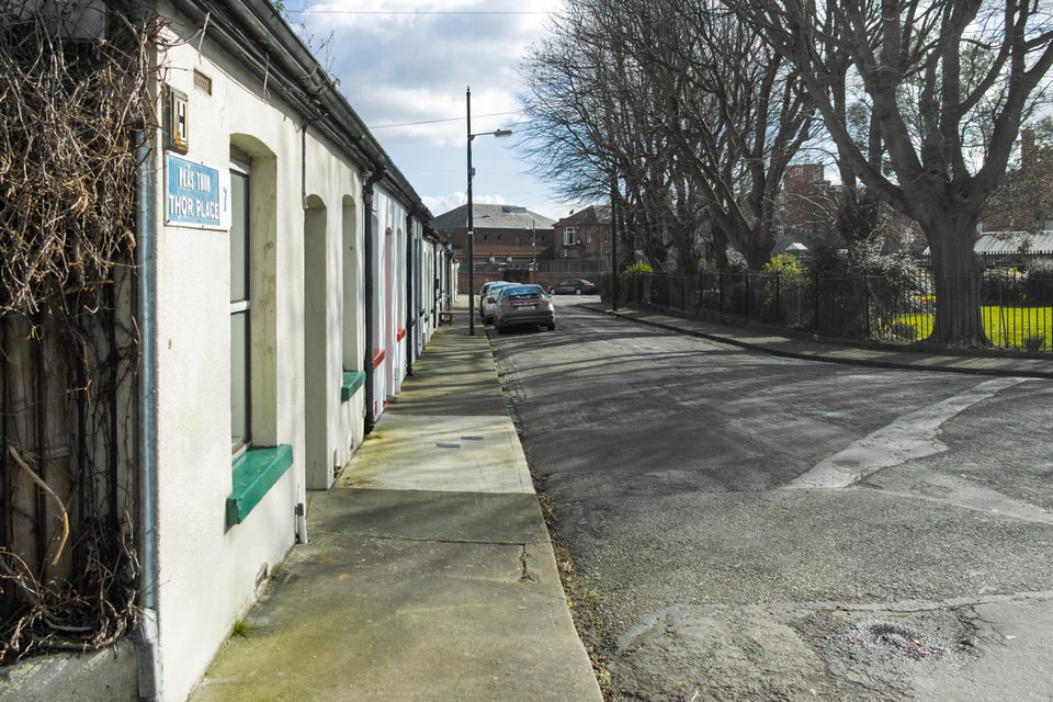
I recently visited Thor Place and the immediate environs, and was struck by the sheer scale of the O’Devaney Gardens redevelopment. To stand there in February 2026 is to experience a radical architectural shift, but for me, the impact is sharpened by the memory of my previous visit exactly five years ago.
February 2021: The Silent Interregnum
When I last walked these streets in February 2021, the world was under the heavy blanket of Level 5 COVID-19 restrictions. At that time, the O’Devaney project sat in a forced slumber. Construction had been halted by government mandate, and the site was a vast, empty expanse of cleared land and quiet machinery.
In my 2021 photographs, there are no people. The streets were ghosts of themselves, governed by the "5km limit" and the hush of a city in hibernation. I chose to use a Sigma DP1 Quattro for that session. Its idiosyncratic, slim profile allowed me to move through the neighbourhood without the intrusive profile of a professional DSLR. It was an ideal camera for a sensitive time, yet its Foveon sensor captured the granular reality of the stalled site with startling, medium-format-like clarity—the rusted fences, the winter grit, and the vast, open sky that has since been colonised by steel.
The Village and the Viking
Stoneybatter is widely regarded as one of Dublin's most characterful neighbourhoods, a "village within the city" famed for its red-brick terraces and artisan dwellings. Yet, beneath the Victorian architecture lies a much older heritage, and rising above it is a contentious modern future.
The district surrounding Thor Place stands on the footprint of Oxmantown, the final stronghold of Dublin’s Vikings. Walking through these streets today reveals a fascinating layering of history: ancient Norse echoes enshrined in street names, the intimate social history of hidden green spaces, and the looming impact of the O'Devaney Gardens redevelopment.
Oxmantown: The City of the "Ostmen"
The history of this enclave began in conflict. Following the Anglo-Norman capture of Dublin in 1170, the city’s Hiberno-Norse population—known as the "Ostmen" or Men of the East—was expelled from the walled citadel. Displaced but not defeated, they crossed the River Liffey and established a new settlement on the north bank.
This settlement became Ostmanby (Oxmantown), a distinct suburb that maintained its own customs and autonomy for centuries. While the wooden longhouses of that era have vanished, the geography of the Viking settlement aligns closely with modern-day Stoneybatter and Smithfield.
A Cartographic Memorial
The Victorian and Edwardian town planners who built the current housing stock chose to honour this lineage through street names, creating a permanent "Viking Network" in stone and brick:
Thor Place: Named for the Norse god of thunder.
Sitric Road: A tribute to the Norse Kings of Dublin.
Olaf & Viking Roads: Direct references to the Scandinavian settlers.
February 2026: The Shadow of "Montpelier"
Today, that 2021 silence has been replaced by the rhythmic clanging of a site in its final push. What was a void five years ago is now Montpelier—the official name for the new O’Devaney quarter.
The character of this historic Viking enclave now faces a dramatic challenge. The area has historically been defined by its low-rise, human-scale architecture—rows of single-storey, red-brick artisan cottages. This aesthetic is now starkly contrasted by the massive redevelopment. As of this month, the first residents are beginning to move into the initial phase of nearly 400 social and affordable homes, but the sheer verticality of the 1,000-unit masterplan has permanently altered the local horizon.
The Canyon Effect: The scale of the new apartment blocks dwarfs the existing single-storey homes, creating what locals describe as a "canyon effect."
Loss of Light: Streets like Thor Place, which I photographed under wide-open, albeit grey, skies in 2021, now face long shadows cast by high-rise structures.
Conclusion
From the exiled "Ostmen" establishing a new life across the river to the pensioners of Thor Place, and now the new residents of Montpelier, this pocket of Dublin 7 is defined by resilience. My 2021 photographs serve as a silent "before"—a record of a site in waiting—while the 2026 reality is a loud, vertical "after" that proves history in Stoneybatter is never static.
GALWAY CITY
CORK CITY AND COUNTY
GLOBAL MENU
DUBLIN SOUTHSIDE
DUBLIN NORTHSIDE
URBAN CARTOGRAPHER
EXCELLENT PICTURE THIS 2017
O'Devaney Gardens As It Was In 2021 - Presented By The Urban Cartographer
Who Is Building An Experience Which Is Getting Better Day By Day