Maynooth Train Station As It Was In 2016 - Presented By The The Urban Cartographer
LET MISTER SCREEN ASSIST YOU
GLOBAL INDEXThe Urban Cartographer
TECHNICAL STUFFMaynooth has undergone an impressive infrastructure transformation over the past decade. The town has successfully integrated its deep-rooted heritage with modern transport links and active travel corridors, creating an exceptionally scannable environment for architectural and landscape documentary.
DUBLIN NORTHSIDE
Maynooth Train Station As It Was In 2016 - Presented By The The Urban Cartographer
Maynooth Train Station As It Was In 2016
Author: The Urban Cartographer
|
28. May 2026
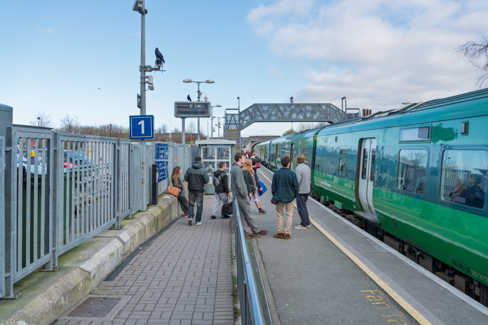
You may notice that auto-focus was not as good as it could have been. BACK IN 2016 I USED A SONY A7RII AND TOMORROW MY A7RVI IS SCHEDULED FOR DELIVERY Maynooth has undergone an impressive infrastructure transformation over the past decade. The town has successfully integrated its deep-rooted heritage with modern transport links and active travel corridors, creating an exceptionally scannable environment for architectural and landscape documentary. Maynooth Train Station Upgrades For many years, the historical 1840s station layout struggled under the weight of surging passenger numbers from the university population and a expanding commuter belt. Since 2016, a comprehensive accessibility and capacity overhaul has completely modernised the hub: < The Harbour and The Royal Canal Directly adjacent to the station lies Maynooth Harbour, an absolute gem for composition. Built as a vital transport link in the late 18th century, the harbor area has shifted beautifully from a commercial industrial basin into a serene public parkland and a focal point for heritage preservation. The still waters reflect the classic stone masonry of the canal locks, traditional lock-keeper cottages, and mature treelines. It offers brilliant framing opportunities where industrial-era engineering intersects with nature—perfect for capturing high-frequency detail, stone textures, and subtle tonal gradations in shifting Irish light. Active Travel: The Royal Canal Greenway The development of the Royal Canal Greenway has been one of the most significant infrastructure achievements in the region since 2016. What was once a narrow, muddy, and often fragmented grass towpath has been systematically transformed into a world-class, multi-user active travel trail. I Plan To Visit Maynooth Early Next Week I THe A7RVI Arrives A Decade of Photographic Evolution A decade creates an incredible contrast in capabilities. Documenting Maynooth back in 2016 required managing a massive amount of fine architectural detail along the canal locks and university stone facades with the Sony A7RII. While its 42.4-megapixel sensor was pioneering for its time, its autofocus systems and handling speed required a methodical, deliberate pace. Our brand-new Sony A7RVI, arriving tomorrow, 29 May 2026, represents an entirely different class of engineering. Stepping out into Maynooth today means pairing extreme high-resolution capabilities with deep-learning AI autofocus algorithms, vastly superior in-body image stabilisation, and massive dynamic range improvements. Capturing the precise geometry of the new station footbridge or the intricate stonework around the harbor, handheld and in unpredictable elements, will feel like a night-and-day evolutionary leap. Keywords: Maynooth Train Station, Royal Canal Greenway, Maynooth Harbour, Irish Rail upgrades, Kildare active travel, transport infrastructure, canal towpath, architectural photography, Sony A7RII, William Mutphy, February, 2016, Infomatique, Legacy, Photo Blog, The Urban Cartographer,
                  [ Maynooth Harbour Basin ]
                              |
     +------------------------+------------------------+
     |                                                 |
[Westward Trail]                               [Eastward Trail]
To Kilcock, Mullingar & Longford               To Leixlip & Dublin City Centre
(130+ km fully off-road)                       (Kildare section completed late 2025)
HIGH RESOLUTION PHOTOGRAPHS
SONY A7RII
MAYNOOTH STATION JULY 2024
GLOBAL INDEX OF PHOTO GALLERIES
DUBLIN SOUTHSIDE
THE URBAN CARTOGRAPHER
DUBLIN NORTHSIDE
Maynooth Train Station As It Was In 2016 - Presented By The The Urban Cartographer
Who Is Building An Experience Which Is Getting Better Day By Day