How Henrietta Place And Street Are Related - Presented By The The Urban Cartographer
LET MISTER SCREEN ASSIST YOU
GLOBAL INDEXThe Urban Cartographer
TECHNICAL STUFFDiscover the fascinating history of Henrietta Street and Henrietta Place in Dublin. Learn how these two interconnected streets evolved from the peak of 18th-century Georgian luxury to Europe's most densely populated tenements, and their modern-day preservation.
DUBLIN NORTHSIDE
How Henrietta Place And Street Are Related - Presented By The The Urban Cartographer
How Henrietta Place And Street Are Related
Author: The Urban Cartographer
|
30. May 2026
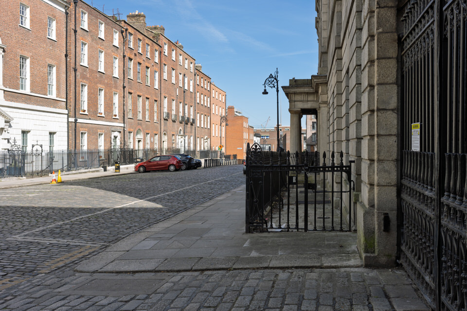
The Relationship Between Henrietta Street and Henrietta Place Henrietta Street and Henrietta Place in north inner-city Dublin are intrinsically linked through their origin and functional layout within 18th-century urban planning. Henrietta Street was designed as a grand, exclusive residential cul-de-sac for the elite of Irish society. To support the lavish lifestyles of its residents without disrupting the architectural grandeur of the main thoroughfare, secondary service lanes were constructed behind the palatial houses. Henrietta Place developed primarily as one of these rear service areas (often containing stable lanes and mews). It provided access to the back of the properties on the northern side of Henrietta Street, allowing coaches, horses, deliveries, and servants to move discreetly without impacting the manicured presentation of the main street. Over the centuries, as the social status of the area transformed, the relationship evolved from a master-servant architectural hierarchy to interconnected urban corridors heavily impacted by the tenement crisis. The History of Henrietta Street Henrietta Street is widely celebrated as the earliest and most intact Georgian street in Dublin.
The Golden Era (1720s–1800): The street was laid out in the late 1720s by the prominent banker and property developer Luke Gardiner. It was named after Henrietta Fitzroy, Duchess of Grafton, or alternatively Henrietta Cavendish, wife of the Lord Lieutenant. Gardiner envisioned a street of unparalleled scale, commissioning massive palatial townhouses designed by leading architects of the era, including Sir Edward Lovett Pearce. It quickly became known as "Primate's Hill" because it housed four All-Ireland Archbishops, alongside peers of the realm, senior judicial figures, and members of the Irish Parliament. The Decline and Act of Union (1800–Late 19th Century): The political landscape ruptured with the Act of Union in 1800, which dissolved the Irish Parliament and merged it into Westminster. Dublin's high society rapidly relocated to London, leaving their massive properties behind. For a few decades, the houses were occupied by legal professionals due to their proximity to the King’s Inns. However, by the mid-to-late 19th century, the properties were bought up by landlords and speculators who stripped out internal partitions to maximise profit. The Tenement Era (Late 19th–Mid 20th Century): By the turn of the 20th century, Henrietta Street had deteriorated into one of the most densely populated slum quarters in Europe. The 1901 census recorded over 800 people crammed into just over a dozen houses. Families lived in single rooms under squalid conditions, a stark and tragic contrast to the building's opulent plasterwork and grand staircases.
Conservation and Present Day: In the latter half of the 20th century, efforts by preservation groups saved the street from total demolition. Today, it stands as a unique cultural anchor, most notably hosting the social history museum at 14 Henrietta Street, which documents the profound journey from palatial townhouse to tenement. The History of Henrietta Place Henrietta Place shared the geographical fortunes of its grand neighbour but experienced history from the perspective of an essential utility lane. 18th-Century Utility: During the Georgian era, Henrietta Place housed the stables, coach houses, and modest dwellings for grooms and domestic staff. The architecture here was vernacular and functional, built with durable brick or stone, contrasting sharply with the ashlar granite façades and classical proportions of Henrietta Street. 19th and 20th-Century Density: As Henrietta Street collapsed into tenement use, Henrietta Place followed a similar trajectory. The former mews and workshops were partitioned into industrial spaces, small tenements, or informal housing. It became a bustling, congested lane supporting small local trades, laundries, and marginalised communities who could not afford space on the main streets. Modern Redevelopment: By the late 20th and early 21st centuries, Henrietta Place became a focus for urban regeneration and sensitive infill developments. Parts of the lane have been modernised into contemporary apartments and office spaces, while other sections continue to support social services and community groups, mirroring the complex architectural and social layers of the inner city. Keywords: Henrietta Street, Henrietta Place, Dublin history, Georgian architecture, Luke Gardiner, Dublin tenements, Irish social history, mews lanes, 14 Henrietta Street, Dublin inner city, Sony A7RVI, May 2026, Photoblog, Streets Of Dublin, William Murphy, Infomatique, Photonique, The Urban Cartographer,
 Kings Inns Public Park - Select Image To View Photographs
HIGH RESOLUTION PHOTOGRAPHS
SONY A7RVI
KINGS INNS IS WORTH A VISIT
GLOBAL INDEX OF PHOTO GALLERIES
DUBLIN SOUTHSIDE
THE URBAN CARTOGRAPHER
DUBLIN NORTHSIDE
How Henrietta Place And Street Are Related - Presented By The The Urban Cartographer
Who Is Building An Experience Which Is Getting Better Day By Day