Hibernian Road And Pedestrian Bridge - Presented By The The Urban Cartographer
LET MISTER SCREEN ASSIST YOU
GLOBAL INDEXThe Urban Cartographer
TECHNICAL STUFFExplore the industrial history of Hibernian Road in Cork City, from its 19th-century railway terminus to the iconic white pedestrian bridge spanning the South Link Road. Discover how this vital infrastructure preserves pedestrian access in a changing urban landscape.
EXCELLENT PICTURE THIS 2017
Hibernian Road And Pedestrian Bridge - Presented By The The Urban Cartographer
Hibernian Road And Pedestrian Bridge
Author: The Urban Cartographer
|
01. May 2026
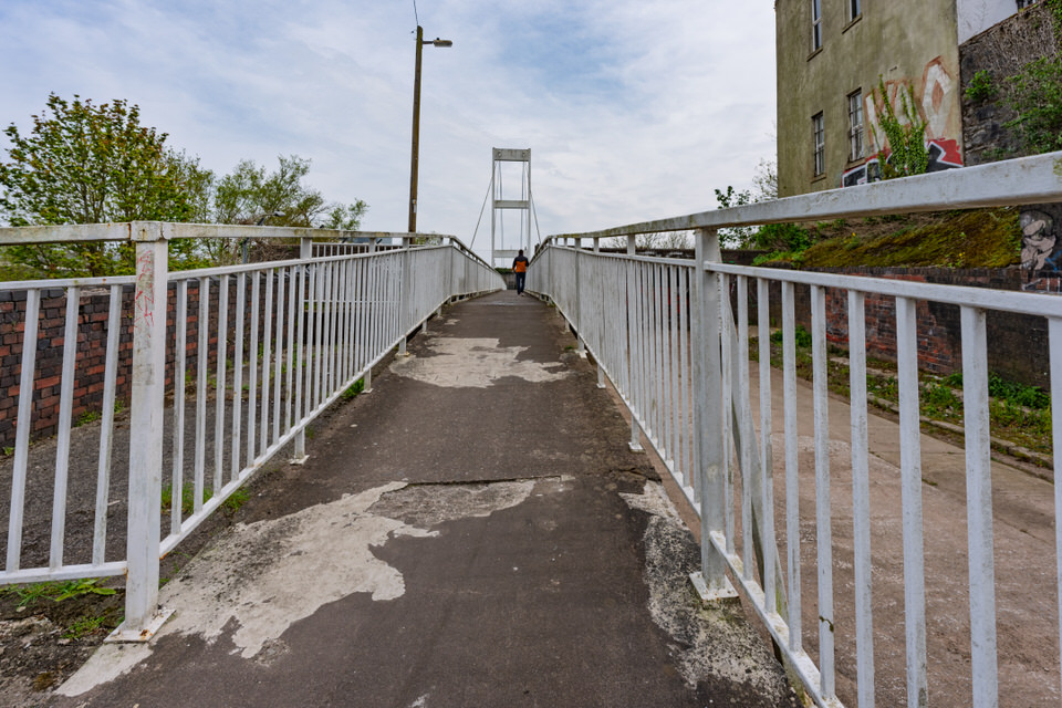
Located near the South Infirmary Victoria University Hospital, Hibernian Road stands as a quiet witness to the radical industrial and infrastructural shifts of Cork City. Originally part of the reclaimed Monarea Marshes, this area transformed during the 19th century into a thriving hub of commerce. The street’s historical identity was defined by the Cork, Blackrock and Passage Railway, which established its terminus here in 1873. This railway heritage catalyzed the construction of the red-brick warehouses and offices—such as the distinctive "Rocksavage Structure" from the early 1920s—that still provide the road with its unique architectural character. Throughout the 20th century, the road remained a centre for local industry, housing notable businesses like Hosford Ltd bakeries and industrial suppliers. A focal point for modern urban photography is the Hibernian Road Pedestrian Bridge, as seen in some of my photographs. This white-painted steel suspension-style structure is more than just a crossing; it is a vital umbilical cord for the city's pedestrians. Key Insights: The Construction: While a crossing existed previously, the current bridge was integrated into the city’s network during the construction of the South Link Road (N27) in the mid-1980s. The Purpose: It was built to maintain a safe North-South connection between the South Parish and eastern suburbs after the dual carriageway was excavated, preventing the severance of historic pedestrian routes. The Design: As evidenced in Bridge-269663.jpg, the bridge features a prominent white frame with a lattice-work safety design. Refurbishment: The current white finish resulted from extensive refurbishment, which involved grit blasting and the application of a high-specification coating to protect the steel from the corrosive environment above the live dual carriageway. The Hibernian Road Pedestrian Bridge acts as the primary link between the industrial heritage of Hibernian Road and the adjoining Rockboro Road and Gas Works Road. These two thoroughfares operate effectively as a single continuous route that has defined the industrial and utility landscape of Cork's south-east ward for nearly two centuries. Rockboro Road: From Residential to Transit Hub Rockboro Road serves as a transitional space between the residential terraces of the South Parish and the industrial zones closer to the River Lee. History: The road was historically bounded by terraced houses that fronted directly onto the street. Its development was closely tied to the expansion of the city beyond the old Monarea Marshes, providing access to the villas and cottages that began to line the outskirts of Cork in the early 19th century. Current Status: Today, Rockboro Road is a one-way street from Old Blackrock Road until its junction with Gas Works Road, where it becomes two-way. It remains a critical, though narrow, artery for local access. Under current city planning, such as the BusConnects Cork project, there are proposals to restrict through-traffic on Rockboro Road to create a safer environment for pedestrians and cyclists, effectively turning it into a "quiet street" for local use. Gas Works Road: The Engine of Cork’s Infrastructure As its name implies, this road was the industrial heart of Cork's energy sector for over 150 years. History: The road was dominated by the Cork Gas Consumers' Company, which acquired a three-acre site here in the mid-19th century. The gasworks were a massive operation; coal was brought in by river boats to produce the gas that lit Cork’s 3,750 street lamps and powered its homes until the mid-20th century. The area was a hive of activity, featuring massive gasometers (storage tanks) that became landmarks of the city skyline. Current Status: The industrial gas production has long since ceased, leaving the road in a state of transition. While some original structures remain—including the Gas Networks Ireland (GNI) offices—much of the land was earmarked for major brownfield redevelopment. Although some apartment projects stalled during economic downturns, the road remains a primary route for those accessing the city from the east and south-east, often serving as a shortcut to avoid the heavy traffic at the Anglesea Street junction. The Bridge Connection The white pedestrian bridge, seen in some of my photographs, is the only link that allows these roads to function as a cohesive pedestrian corridor over the South Link Road. Future plans for the area suggest a significant upgrade: the current narrow bridge is proposed for replacement with a wider, more accessible structure to better accommodate the increasing number of cyclists and commuters moving between the Shalom Park area and the city centre. Hibernian Road - Select Image To View Photographs
 Elevated Walkway - Select Image To View Photographs
 The Art And Arist - Select Image To View Photographs
 Daly's Bridge - Select Image To View Photographs
 Abstract Sculptures - Select Image To View Photographs
 Lost Industries Sculpture - Select Image To View Photographs
 By Denis O'Connor - Select Image To View Photographs
 By Sandra Bell - Select Image To View Photographs
VIEW HI-RES PHOTOGRAPHS
CORK CITY AND COUNTY
HIBERNIAN ROAD AND BRIDGE
GLOBAL INDEX OF PHOTO GALLERIES
APRIL 2026 PHOTO COLLECTION
THE URBAN CARTOGRAPHER
EXCELLENT PICTURE THIS 2017
Hibernian Road And Pedestrian Bridge - Presented By The The Urban Cartographer
Who Is Building An Experience Which Is Getting Better Day By Day