The River Nore February 2026 - Presented By The The Urban Cartographer
LET MISTER SCREEN ASSIST YOU
GLOBAL INDEXThe Urban Cartographer
TECHNICAL STUFFTravel plans for Kilkenny’s River Nore walks are frequently impacted by flooding and waterlogged ground. While Kilkenny City has established flood defences, many rural trails remain vulnerable due to environmental protections and the prioritisation of residential areas in national flood relief programmes.
EXCELLENT PICTURE THIS 2017
The River Nore February 2026 - Presented By The The Urban Cartographer
The River Nore February 2026
Author: The Urban Cartographer
|
01. Mar 2026
Photographed By William Murphy - Select Image To View Photographs

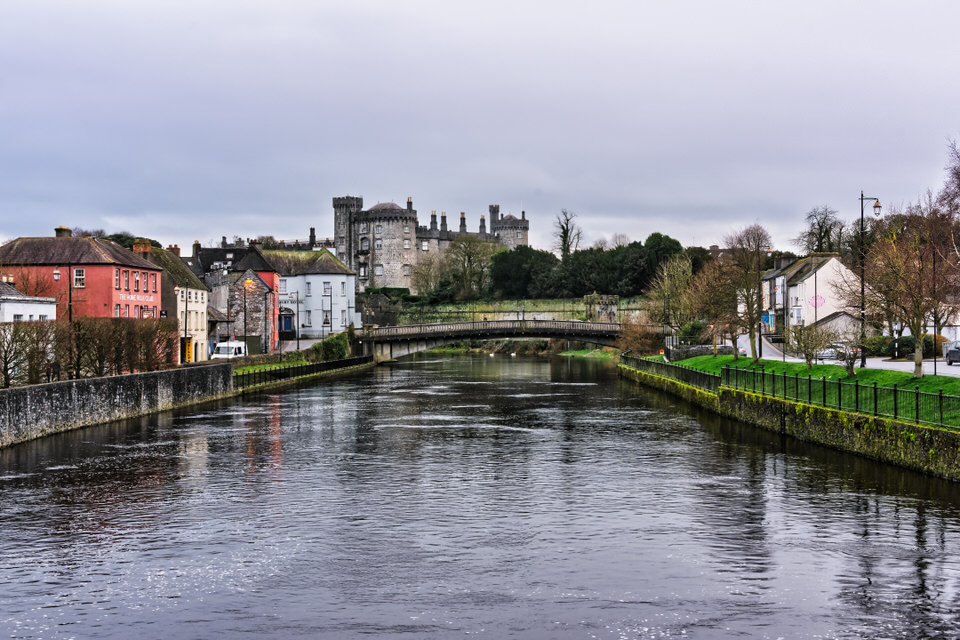
It is incredibly frustrating when a long-anticipated trip is dampened by the very landscape I came to explore. The River Nore is the literal and metaphorical heart of Kilkenny, but as I experienced, it is a high-energy river system that can transform from a scenic backdrop into an impassable floodplain with very little warning.
The Current Situation
The walks that I had planned to explore, such as the Nore Valley Walk or the trails toward Bennettsbridge and Inistioge—are primarily "soft" infrastructure. Because they run through natural floodplains, they are designed to accommodate seasonal rising waters rather than fight them. During periods of heavy rain (which have been particularly frequent in early 2026 following Storm Chandra), these areas become "waterlogged" by design.
The muddy, impassable state of the trails is often a result of the high silt content in the Nore’s "alluvial" soil, which retains moisture long after the actual floodwaters have receded.
Why the Lack of Infrastructure?
It may seem like there is a lack of defence, but the reality is more complex. Flood management in Ireland is governed by a "cost-benefit" and "environmental impact" framework that often clashes with the desire for immediate structural fixes:
Priority Ranking: The Office of Public Works (OPW) prioritises "hard" defences (walls and embankments) for high-density urban areas where homes and businesses are at risk. Kilkenny City actually has a multi-million euro flood relief scheme (completed around 2006) that protects the city centre, but this does not extend to the rural walking trails.
Environmental Protection: The River Nore is a Special Area of Conservation (SAC) and a Special Protection Area (SPA). Building hard concrete defences along scenic walking trails would require massive environmental offsets and could potentially damage the habitats of protected species like the Freshwater Pearl Mussel or Kingfishers.
Downstream Impact: Defending a walking trail with a wall often simply pushes the water further downstream, potentially flooding a village like Thomastown or Inistioge even more severely.
Plans for the Future
There is movement, though it is often slower than locals and visitors would like:
Active Schemes: Major flood relief projects are currently in various stages of planning and "pilot data collection" for Graiguenamanagh-Tinnahinch, Ballyhale, Freshford, and Piltown.
The "Tranche" System: Thomastown and Inistioge are part of a second wave of planned schemes. While not yet under construction in early 2026, they are on the national roadmap for "hard" and "soft" defences.
Trail Upgrades: Trail Kilkenny and the County Council have ongoing objectives to upgrade the Nore Valley Walk, including better drainage and the completion of the "missing link" between Bennettsbridge and Thomastown, though these remain subject to environmental "Appropriate Assessments."
GALWAY CITY
CORK CITY AND COUNTY
GLOBAL MENU
DUBLIN SOUTHSIDE
DUBLIN NORTHSIDE
URBAN CARTOGRAPHER
EXCELLENT PICTURE THIS 2017
The River Nore February 2026 - Presented By The The Urban Cartographer
Who Is Building An Experience Which Is Getting Better Day By Day