Exploring Monahan Road In Cork City - Presented By The The Urban Cartographer
LET MISTER SCREEN ASSIST YOU
GLOBAL INDEXThe Urban Cartographer
TECHNICAL STUFF
VIEWS OF CORK HARBOUR
Exploring Monahan Road In Cork City - Presented By The The Urban Cartographer
Exploring Monahan Road In Cork City
Author: The Urban Cartographer
|
18. May 2026
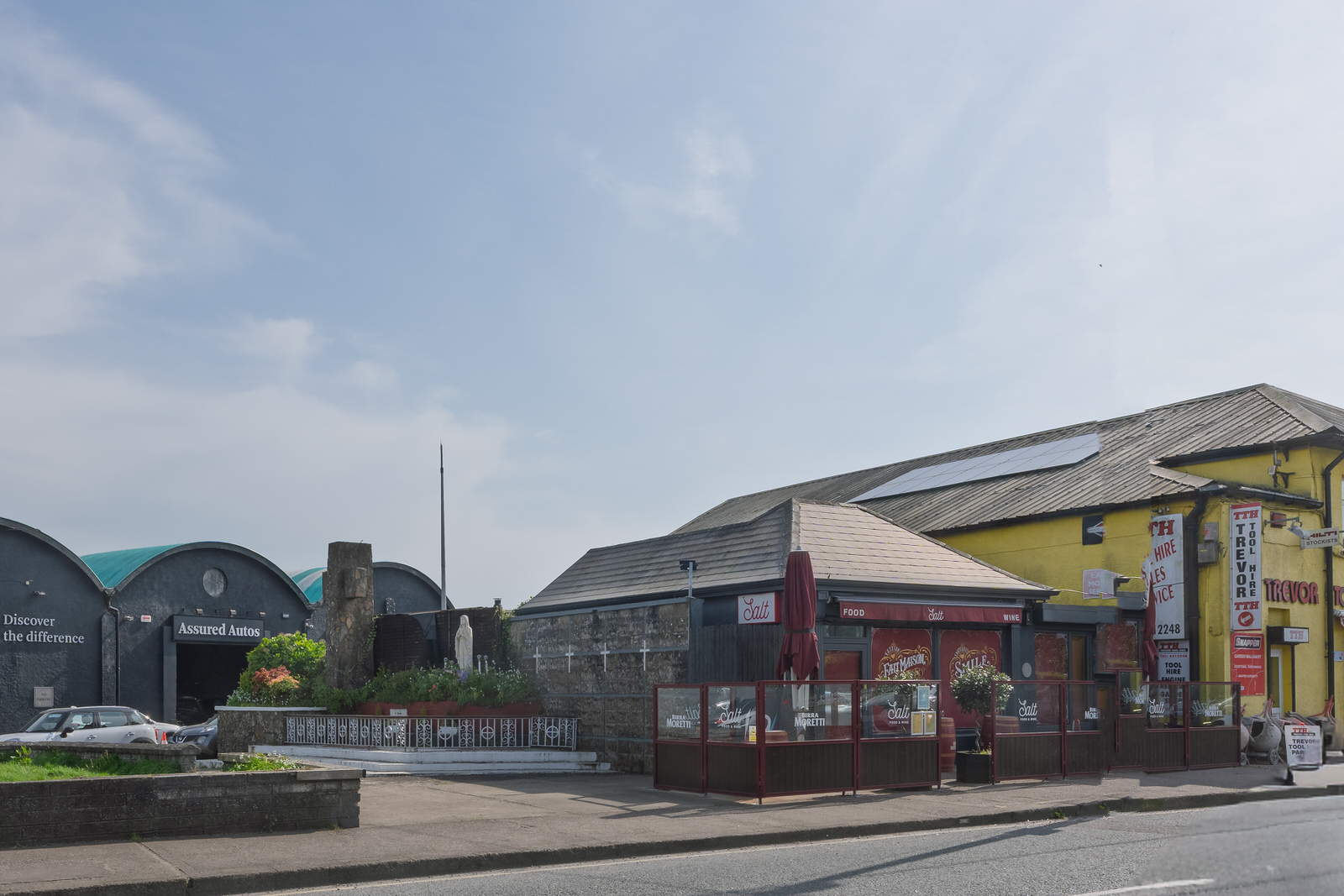
Monahan Road: History and Redevelopment Historical Context Monahan Road, alongside Centre Park Road, serves as a spine for Cork’s South Docks. This entire district sits on "slob land"—low-lying marshland systematically reclaimed in the nineteenth century using dredging material extracted from the bed of the River Lee. The road itself is synonymous with the industrial transformation of Cork. In 1917, Henry Ford established the first purpose-built Ford manufacturing plant outside the United States on these reclaimed parklands, rolling out Fordson tractors by 1919. Shortly thereafter, in the 1930s, Irish Dunlop commenced massive tyre production on the eastern portion of the site. For decades, this corridor was a dense, gritty landscape of manufacturing, heavy transport, and coal yards. The subsequent closure of these major plants by 1984 left behind a landscape dominated by vast, weathered corrugated-iron warehouses, concrete depots, and expansive commercial parking spaces—the very factors contributing to its current uninviting, grey aesthetic. Redevelopment Plans The "ugly and unattractive" industrial corridor is currently at the epicentre of the Cork Docklands Redevelopment scheme, a multi-billion-euro project of national strategic importance under the Cork City Development Plan. The framework intends to transform 147 hectares of brownfield land into a high-density, mixed-use urban quarter. The Monahan Road Extension (MRE): This key infrastructural scheme involves realigning the eastern end of Monahan Road near Marquee Road, upgrading junctions, and extending a new multi-modal, four-lane transport corridor north-eastwards. This extension is designed to tie into the proposed Eastern Gateway Bridge, connecting the South Docks directly to Tivoli across the River Lee. The Marina Market Transition: The industrial warehouses that dictated the road's mid-section appearance are seeing creative adaptive reuse. The highly successful Marina Market, housed in a former Ford distribution building, is slated for a major €100-million redevelopment designed by Níall McLaughlin Architects. Plans include transforming the site into a permanent cultural hub featuring a contemporary art gallery, an events and convention centre, and a hotel, adopting a refined industrial aesthetic suited for a low-carbon era. Ford Square & Residential Zoning: The surrounding commercial blocks are zoned to become "Ford Square" and a new district centre, converting the industrial gap between the two parks into walkable, tree-lined neighbourhoods featuring thousands of new homes. The Two Parks Marina Public Park Located at the eastern end of Monahan Road, adjacent to the iconic Páirc Uí Chaoimh GAA stadium, Marina Park is a state-of-the-art 14-hectare urban park acting as a "green lung" for the South Docks. The site carries a varied history; it originally formed part of the Victoria Park Racecourse (opened in 1869) and later served as the showgrounds for the Munster Agricultural Society. The modern park layout represents a sophisticated piece of landscape architecture that embraces its industrial and natural constraints. It is designed around water management and biodiversity, incorporating the historic Atlantic Pond and a network of marshes, reed beds, and modern water plazas that double as natural flood mitigation. The architectural language features striking, minimal steel pavilions, modern bridges, and extensive active-travel pathways that connect seamlessly with the pedestrianised Marina Promenade along the river. Kennedy Park The park was formally named in honour of US President John F. Kennedy following his historic state visit to Cork in June 1963. In fact, President Kennedy’s helicopter departed from this exact location during his tour. Historically, it holds deep community and sporting significance; it served as the original homestead for the famous Nemo Rangers GAA club during their infancy and remains a heavily used public amenity for local soccer, tag rugby, and American football training. The Marian Grotto at Albert Road / Victoria Road Where Monahan Road reaches its western terminus and transitions toward the city centre via Victoria Road and Albert Road, the urban landscape gives way to a notable piece of mid-twentieth-century public devotion: the Albert Road Marian Grotto. Monahan Road - Select Image To View Photographs
 Historic Cork South Side April 2026 - Select Image To View Photographs
 My September 2025 Visit To Fin Barres - Select Image To View Photographs
 Fin Barres Cathedral Leica Q3 Session - Select Image To View Photographs
 Peoples Republic Art - Select Image To View Photographs
 Egawa Sushi 18 Kyle Street Cork - Select Image To View Photographs
 Elevated Walkway - Select Image To View Photographs
 The Art And Arist - Select Image To View Photographs
 Onion Seller - Select Image To View Photographs
 Abstract Sculptures - Select Image To View Photographs
 Lost Industries Sculpture - Select Image To View Photographs
 By Denis O'Connor - Select Image To View Photographs
 By Sandra Bell - Select Image To View Photographs
QUICK AND EASY PHOTO GALLERY
SONY A1 II
ABOUT MONAHAN ROAD
GLOBAL INDEX OF PHOTO GALLERIES
CORK CITY AND COUNTY
THE URBAN CARTOGRAPHER
VIEWS OF CORK HARBOUR
Exploring Monahan Road In Cork City - Presented By The The Urban Cartographer
Who Is Building An Experience Which Is Getting Better Day By Day