Dyke Road Has Changed Since 2019 - Presented By The The Urban Cartographer
LET MISTER SCREEN ASSIST YOU
GLOBAL INDEXThe Urban Cartographer
TECHNICAL STUFFExplore the dramatic transformation of Galway's historic Dyke Road. From its origins as a Great Famine relief project to the current Corrib Causeway redevelopment, we look at why the landscape has changed from a wild thicket to a modern construction site in April 2026.
EXCELLENT PICTURE THIS 2017
Dyke Road Has Changed Since 2019 - Presented By The The Urban Cartographer
Dyke Road Has Changed Since 2019
Author: The Urban Cartographer
|
04. Apr 2026
 Dyke Road 2026 - Select Image To View Photographs
Note: I visited area twice during my week long visit to Galway. For the first session I used a Fuji GFX100RF medium format camera and because of rain, fog and mist and other problems I was not happy with the resulting images. For the second visit I used a Sony A1 MkII and the 100mm Macro lens and the results were somewhat superior.
Transformation of the Dyke Road: From Famine Relic to Modern Parkway.
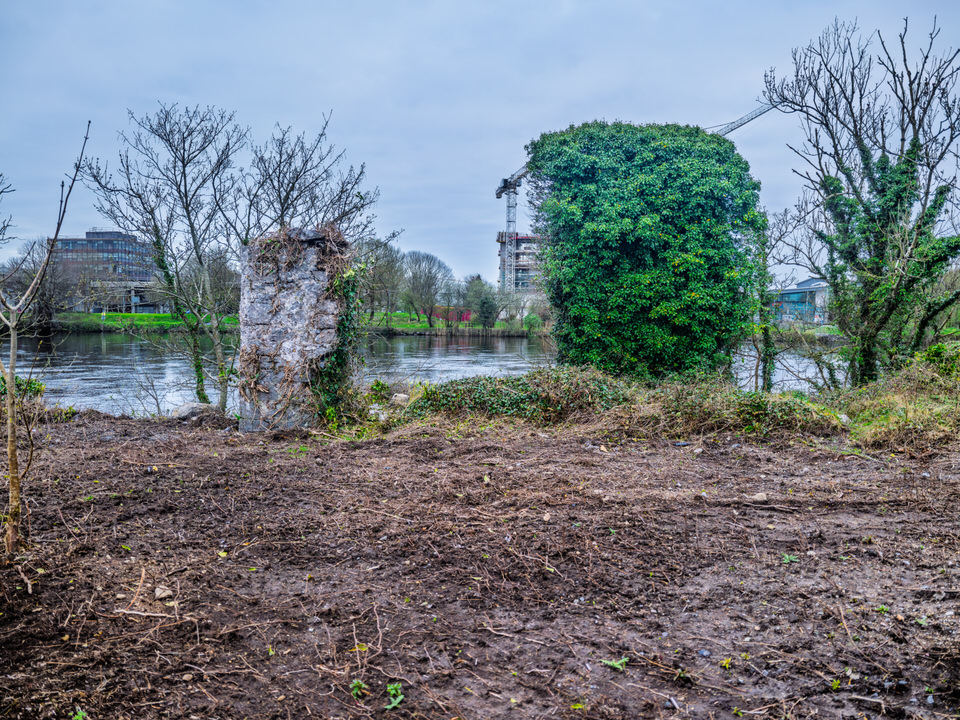
It has been seven years since I last photographed the Dyke Road in Galway, and to be honest, I was shocked by the transformation. Had the Black Box Theatre not been visible nearby I might have been convinced I had arrived at the wrong location entirely.
What was once a wild, impenetrable thicket in 2019 has become a stark "no-man's land"—a landscape currently suspended between its historic past and its future as a developed urban parkway.
A Legacy Carved in Stone
The history of the Dyke Road is rooted in one of Ireland’s darkest eras. Galway was devastated by the Great Famine (1845–1847), a period in which at least 20% of the local population perished. The Dyke Road itself was a "relief work" project.
Throughout the west of Ireland, the landscape is still scarred by these Famine roads—strange, criss-crossing paths that often climb into the hills and simply stop. Under the harsh "laissez-faire" economic theories of the day and the strictures of the Poor Law, the Irish peasantry were forced into hard labour in exchange for food. Today, these roads remain as 170-year-old scars on the countryside; the stone walls endure, even as the world around them changes.
The Current State: Why Does it Look So Bleak?
The lush greenery I captured seven years ago has vanished, replaced by a dark, industrial landscape. This is the result of the Corrib Causeway project, a major redevelopment led by the Land Development Agency (LDA) and Galway City Council.
1.The "Dangerous" River Side
The riverbank currently feels treacherous. In 2019, a dense "skeleton" of roots from bushes and brambles held the bank together. With these removed for Phase 1 site preparation, the ground is unstable. The striking "black" surface visible in my recent photographs is a combination of:
Exposed Fen Peat: Naturally dark, organic soil that becomes slippery and liquid-like in the Atlantic rain.
Geotextile Membranes: Black "geogrids" laid down by contractors to stabilise the soft bank before paving begins.
Construction Silt: Disturbed earth and voids left behind where old roots and stone footings were extracted.
2.The Waterworks and the Ruins
The old Waterworks building, which stood derelict during my last visit, is finally seeing movement. Planning permission was granted in August 2025 to convert it into a state-of-the-art Water Sports Centre for kayaking and rowing.
Across the road, the ruins near the old Terryland bridge remain. Because this is a sensitive archaeological zone, the LDA is restricted from touching these historic structures. They look particularly abandoned now simply because the "wild" greenery that once framed them has been stripped away, leaving them exposed.
3.The Field
The vast field I once photographed is currently serving as a "staging area." It is a graveyard of soil heaps, pipes, and heavy machinery, awaiting the later phases of the development.
Looking Ahead: April 2026 and Beyond
We are currently in the "it gets worse before it gets better" phase of urban regeneration. The vision for the Dyke Road includes:
Residential Growth: Finalised plans for 219 apartments reaching up to nine storeys.
The Promenade: The black mud will eventually be replaced by limestone paving and a formal promenade linking the Black Box Theatre directly to Woodquay.
The "Blueway": A new pedestrian boardwalk to enhance the city’s connection to the river.
Is the "Green" Coming Back?
For those who mourn the loss of the wild thicket, there is some consolation. The planning conditions strictly require "No Net Loss" of biodiversity. Once the heavy civil engineering is complete, the LDA is mandated to replant the area with native riverine species.
The "wildness" of the Dyke Road has been traded for a managed public parkland. It is a significant shock to the system for those of us who remember its quiet, overgrown solitude, but the transformation of the Corrib's edge is now well and truly underway.**
 Photographed By William Murphy - Select Image To View Photographs
VIEW HI-RES PHOTOGRAPHS
CORK CITY AND COUNTY
ABOUT DYKE ROAD IN APRIL 2026
GLOBAL INDEX OF PHOTO GALLERIES
GALWAY CITY
THE URBAN CARTOGRAPHER
EXCELLENT PICTURE THIS 2017
Dyke Road Has Changed Since 2019 - Presented By The The Urban Cartographer
Who Is Building An Experience Which Is Getting Better Day By Day