Bishopmeadows Walk August 2018 - Presented By The The Urban Cartographer
LET MISTER SCREEN ASSIST YOU
GLOBAL INDEXThe Urban Cartographer
TECHNICAL STUFFA retrospective on Kilkenny's Bishopmeadows trail, comparing the wilder access of 2018 to the structured pathways of 2026. Discussing a shift to minimalist photography with the Leica Q3 and Fujifilm GFX100RF, and how improved bus frequencies have transformed the hiking experience along the River Nore.
EXCELLENT PICTURE THIS 2017
Bishopmeadows Walk August 2018 - Presented By The The Urban Cartographer
Bishopmeadows Walk August 2018
Author: The Urban Cartographer
|
02. May 2026
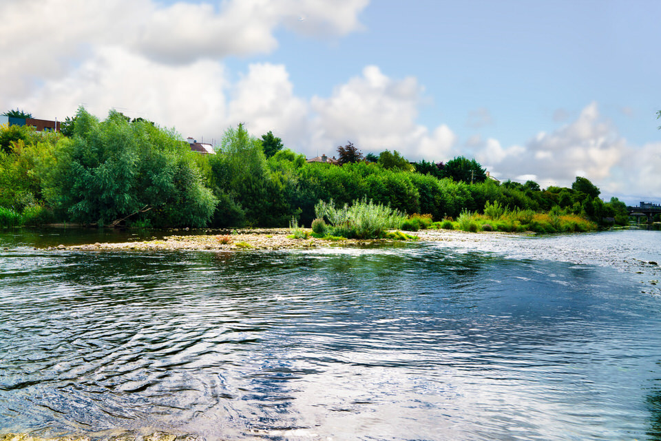
Seeking directions in rural Ireland often leads to the quintessentially local response: "Well, I wouldn’t start from here." This reflects a broader, more philosophical approach to navigation that prioritises landmarks and local lore over metric precision. During the 2018 visit to Kilkenny, an encounter with a local farmer resulted in the Bishopmeadows walk being described as "six fields" long. The Evolution of the Bishopmeadows Walk: From Heavy Glass to Minimalist Precision Reflecting on a visit to Kilkenny’s Bishopmeadows in August 2018 feels like looking back at a different era of both the landscape and the craft of photography. At the time, the "six fields" described by a local farmer seemed like a manageable afternoon stroll, but the reality of a 30km day in sweltering heat—compounded by a heavy Sony A7RIII and a bag of glass—proved to be a physical breaking point. Returning to these trails in 2026, the contrast is stark. The wilder, more porous boundaries of 2018 have been replaced by a more structured, managed environment, mirroring the shift many of us have made toward a lighter, more intentional way of working.
The Landscape: Managed Pathways and Restricted Access One of the most significant changes since 2018 is the formalisation of the Nore Valley Way and the Bishopmeadows stretch. While the trail remains a jewel of Kilkenny’s nature offerings, the "open field" experience captured in older photographs has largely vanished. Fixed Pathways: In line with recent conservation and safety efforts by Trail Kilkenny, much of the route now features fixed fencing and designated gravel or paved paths. Restricted Access: The ability to wander deep into the fields—once a staple for getting unique angles of the River Nore—is now curtailed. This is primarily to protect local biodiversity and prevent the erosion of the riverbanks, but for the photographer, it means a more disciplined approach to composition from the path itself. The "Six Fields" Reality: That local farmer’s estimate of "six fields" remains geographically accurate, but the journey now feels longer because the paths are less direct than the old desire lines through the grass. A Shift in Philosophy: The "One Lens" Rule The exhaustion of 2018 served as a catalyst for a total gear overhaul. The days of lugging battery grips and a "just in case" bag of zooms are over. The modern approach is about adaptation through limitation. By selecting a single focal length before leaving the hotel, the process shifts from technical management to creative problem-solving. If the lens doesn't fit the shot, you don't swap the glass; you change your perspective or commit to returning another day. This minimalist kit is spearheaded by two remarkable fixed-lens powerhouses: Leica Q3: The ultimate street and trail companion, offering a 28mm Summilux that handles the wide vistas of the Nore with legendary micro-contrast. Fujifilm GFX100RF: The 2025 addition to the medium format world. This fixed-lens beast provides 102MP resolution in a body that, remarkably, doesn't require a chiropractor after a day in the field. It allows for incredible cropping flexibility, effectively acting as multiple focal lengths in one. Connectivity: The 20-Minute Threshold The physical toll of the "walk there and back" method has been mitigated by Kilkenny’s vastly improved public transport network. In 2018, relying on a bus to return from the outskirts was a gamble. By 2026, the Kilkenny City Bus Service (KK1 and KK2) and expanded regional links have reached that "sweet spot" of frequency. With buses now running every 20 minutes or better on key corridors, the logistics of a shoot are simple: take the bus to the furthest point of the trail and walk back towards the city centre. This ensures your energy is spent on the hunt for the right light, rather than the slog of a return journey.
History and Context: The Canal and River Walks The Bishopmeadows walk is steeped in the industrial and natural history of the Marble City. The Canal Walk, which begins near Kilkenny Castle, follows the remnants of an ambitious 18th-century project intended to make the Nore navigable to Inistioge. Though the canal was never completed, the towpaths created centuries ago now form the backbone of the city's green lung. Walking from the canal into the Bishopmeadows, you move from the manicured shadow of the Castle into a more riparian, limestone-rich environment that has defined Kilkenny’s "Marble City" moniker for generations. The Ambiguity of Distance: Navigating the "Six Fields" Seeking directions in rural Ireland often leads to the quintessentially local response: "Well, I wouldn’t start from here." This reflects a broader, more philosophical approach to navigation that prioritises landmarks and local lore over metric precision. During the 2018 visit to Kilkenny, an encounter with a local farmer resulted in the Bishopmeadows walk being described as "six fields" long. The "field" is a famously elastic unit of measurement in the Irish countryside, and its meaning fluctuates wildly depending on the regional geography: Regional Variation: In the fertile plains of County Meath, where land was historically divided into vast estates, six fields could easily span three to six miles. The Nore Valley Context: In the limestone-rich terrain of Kilkenny, riparian boundaries along the River Nore tend to be more frequent. In this specific landscape, "six fields" equates more accurately to a distance of between 1.5 and 2 miles. While the distance seems manageable on paper, it failed to account for the "photographer’s tax"—the physical exertion of carrying a heavy Sony system and the necessity of a return journey. The Shift to Fixed Pathways The transition from those open, ambiguous fields to the fixed pathways seen today has redefined the experience. In 2018, "six fields" meant navigating gates, livestock, and unpredictable terrain. By 2026, the formalisation of the trail has "locked" the distance into a designated route. While the installation of fencing and gravel paths prevents access to the specific fields shown in older photographs, it has introduced a level of predictability essential for a modern workflow. This structure allows for a more calculated approach; knowing exactly where the path begins and ends makes it possible to synchronise a shoot with the 20-minute bus frequency now available in the Kilkenny area. The farmer’s "six fields" may remain an imprecise measurement in the mind, but the modern trail has transformed it into a repeatable, manageable circuit perfectly suited for a minimalist, fixed-lens approach. Sculpture - Select Image To View Photographs Bishopmeadows - Select Image To View Photographs
 Th River Nore 2026 Visit - Select Image To View Photographs
 The Laneways - Select Image To View Photographs
VIEW HI-RES PHOTOGRAPHS
KILKENNY 2018
ABOUT BISHOPMEADOWS
GLOBAL INDEX OF PHOTO GALLERIES
BISHOPMEADOWS 2021 VISIT
THE URBAN CARTOGRAPHER
EXCELLENT PICTURE THIS 2017
Bishopmeadows Walk August 2018 - Presented By The The Urban Cartographer
Who Is Building An Experience Which Is Getting Better Day By Day